
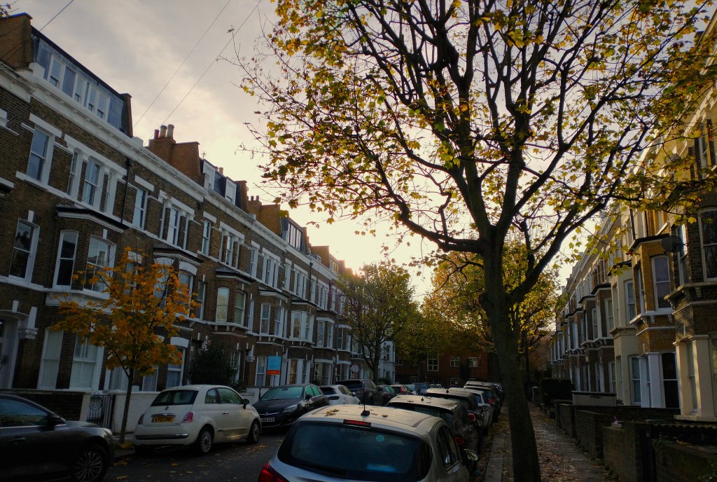
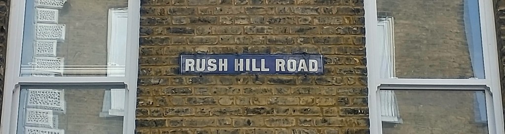
Rush Hill Road is a small street leading off Lavender Hill. We’ve dug in to its past, in the latest of our local history posts.
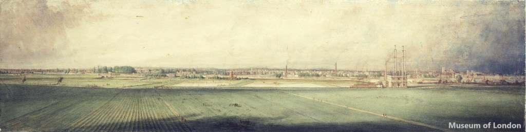
No-one knows who first named the area Rush Hill: at some point a field on the south side of Lavender Hill is recorded as being called Rush Hill, and the name’s stuck ever since. Before the railways arrived the area was a wide open space of fields, with a scattering of large houses with generous gardens. And it was an ideal spot for those houses: being the top of a hill meant there was good air and well-drained ground (with a few natural springs), as well as far-reaching views over Battersea Fields and the Thames to London. Robert Westall’s painting below shows the view in 1848, a few years before the railways arrived and everything changed; a few familiar buildings include Westminster Abbey and Chelsea Hospital; with the pipes of the Battersea Pumping Station in the foreground giving a small taste of future industrial development.
The people living in these scattered houses were wealthy – for some these were weekend retreats from the city, others were retired. The houses were typically quite close to the road with a short drive for carriages; with much larger gardens behind including lawns, ponds, kitchen gardens, and greenhouses to grow fresh fruit and vegetables. Most of these out-of-town properties had some stabling and paddocks, as well as space for cows and pigs, and maybe also separate coach houses.
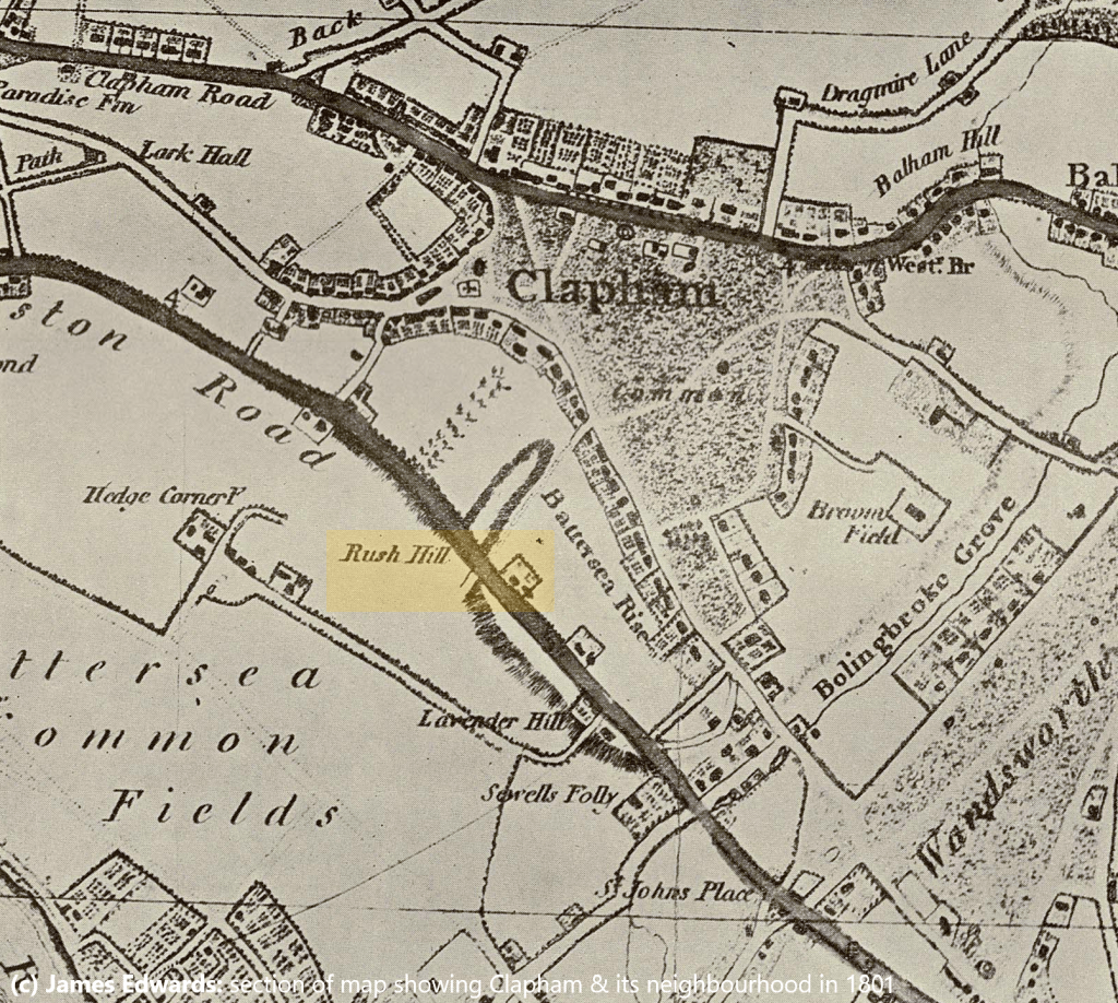
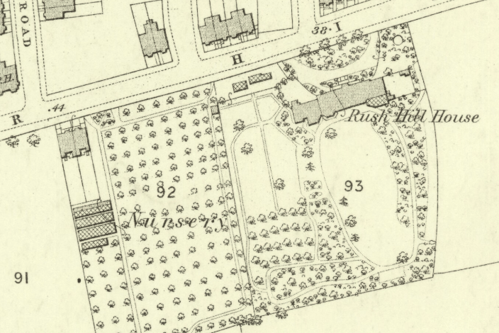
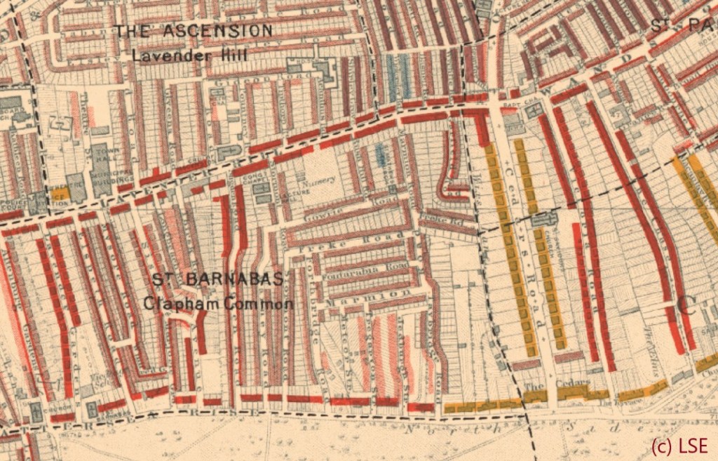
The map above shows the layout in 1801 (and takes a bit of getting used to as North is at the bottom left hand corner). In 1801 there was already a fairly extensive set of houses around all three sides of Clapham Common, the specked shaded area in the middle – with the Lavender Hill (then called Kingston Road) cutting across the map diagonally below it. There are only a scattering of houses shown on the Lavender Hill – but one is visible, right next to the label ‘Rush Hill’. This is the first mention we can find of Rush Hill, and the house in question is Rush Hill House.
Rush Hill House was older than the other houses in the area, and its origins are obscure – we know that it was also a fair bit larger than the other houses, having been built at some stage in the 1700s. It’s mentioned in the will of Hop Factor Thomas Barry in 1770, but described as ‘my two messuages’ in the occupation of Edmund Rush on the south side of the road. A ‘messuage’ is an old word for a house – suggesting that Rush Hill House may initially have been a semi-detached pair of houses that were later combined into one larger residence. By the time it was a single property there were eight bedrooms, and a generously sized 30-by-18-foot drawing room.
It’s the large house in the middle of the map above – complete with a double-ended driveway, a large south facing garden an orchard, and a couple of outbuildings near Lavender Hill.
This first mention of the house also gives a clue to the future name of the street: Edmund Rush was a mason living in Battersea, whose will dated 1782 is held at the National Archives. He was a noted builder in the 1750s and 1760s, responsible for several very upmarket streets in Mayfair including Dunraven Street in Mayfair, part of South Street, and some huge terraces at 5 and 6 Hyde Park Place. It seems that as an early tenant (and possibly a fairly well known one, given he was building some of the most expensive property in London), his name may have ended up attached to the house and the area.
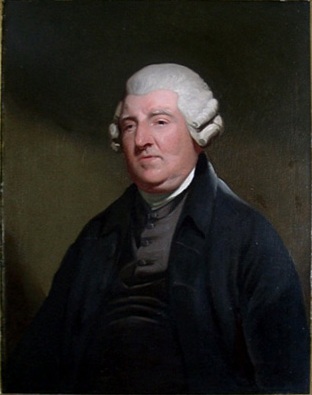
Towards the end of the 1700s, Rush Hill House became the home of Peter Dollond – pictured to the right. Peter had grown up in Kensington, but left the family silk business to set up a shop in Kennington, where he designed and sold some of the best telescopes and optical instruments of the day – conveniently only a short trip from Rush Hill. This went very well indeed, and he built what became the national chain Dollond & Aitchison (which was to survive for several centuries, finally being rebranded to Boots opticians in 2015).
In 1842 Lavender Hill was described as ‘a most respectable and social neighbourhood’, and Rush Hill House went on to house a series of successful City businessmen including John Ashlin, a corn trader; followed by John Harvey, a banker and railway promoter, Intriguingly one of John A’s sons went on to marry John H’s daughter, suggesting that there must have been some sort of link between the successive occupiers. It was still a grant country house, with ten acres of land including a significant landholding to the north side of Lavender Hill.
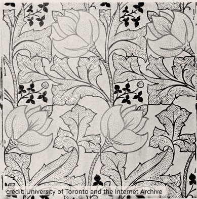
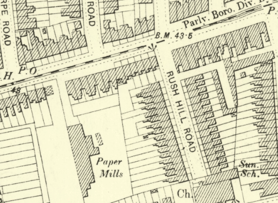
But change was on the way. The railways started their inexorable spread in the 1840s, and were accompanied by all sorts of dubious new neighbours! The first sign of change was Beaufoy’s Acetic Acid factory, which was built in about 1830 by Lambeth vinegar entrepreneur John Beaufoy close to the junction of Lavender Hill and Queenstown Road (and for some time thereafter remembered in the naming of The Beaufoy Arms pub, which appeared at some point before 1870 and survived in one form or other until a few years ago). Much stinkier stuff was to follow to the west, with a Size works being developed near where the Hare & Hounds pub now stands. Size was an early type of light glue, used in painting, and was made in a notoriously smelly process of treating and then boiling animal skins and hooves. The rural surroundings that had made Rush Hill House a popular getaway for over a century started to be replaced with dense new terraced housing aimed at the lower middle classes – at first a tricke of development and gradually a flood of building work as, one by one, the landowners sold their fields to developers. New houses surrounded the villa on three sides, and the previous tree nursery to the west was replaced by Essex & Company’s wallpaper factory – who made products such as the print illustrated to the right – which later went on to make envelopes and house a bus garage (and which is still standing, having been converted to Battersea Business Centre). Outside the house’s front gates Lavender Hill itself was evolving from a country lane to a busy commercial street.
A big smart country villa was looking increasingly out of place in this environment. Rush Hill House was well built and had outlasted most of the old country houses, but by now the writing was well and truly on the wall, and it’s easy to imagine that the later residents – surrounded by terraced houses, noise and strange industrial smells – will have known that the sun was setting on Battersea’s time as a place for big country villas. Sure enough, in 1872 Rush Hill House and its generously sized garden were put up for sale – described as “a favourable opportunity for carrying on successful building operations”.
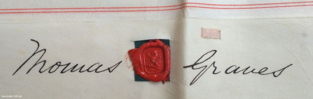
The land was bought and developed by Henry Shadwell Willett (a solicitor at Gray’s Inn, turned property developer) and Thomas Graves (a plumber in Marylebone, turned builder) – reflecting the way everyone who could was trying to get involved in the frenzy of building. On Friday the 4th October 1873 the Borough agreed plans to create a new road, which had been drawn up by their agent H. C. Bunkell, a builder / estate agent based on Holloway Road.
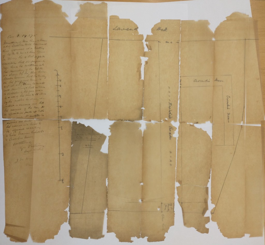
This is where our first archive document comes in: with the help of Wandsworth’s ever-helpful archives we found the original plan for the street, pictured below. The 19th century paper had crumbled a bit over the years, so ended up being a bot of a jigsaw! The clerk’s notes on the left give some insight in to how roads got created: he named the road ‘Rush Hill Road’, named the proposed mews street ‘Crombie Mews’, and approved it only on condition that the proposed road be extended another fifteen feet or so to the south “to the boundary of the estate” and so could in future be connected to to Gowrie Road, that “the proposed mews be not at any future time converted to dwellings“, that “no barrier or obstacles to the free access to + use of the same street + mews by the public are at any time erected or caused“, and that the developer put up a street name sign at each end of the street until the houses were built, at which point the signs were to be fixed to the houses.
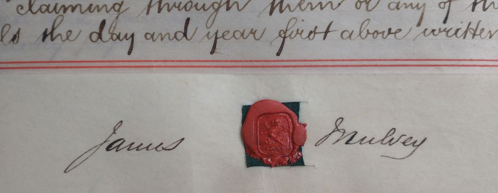
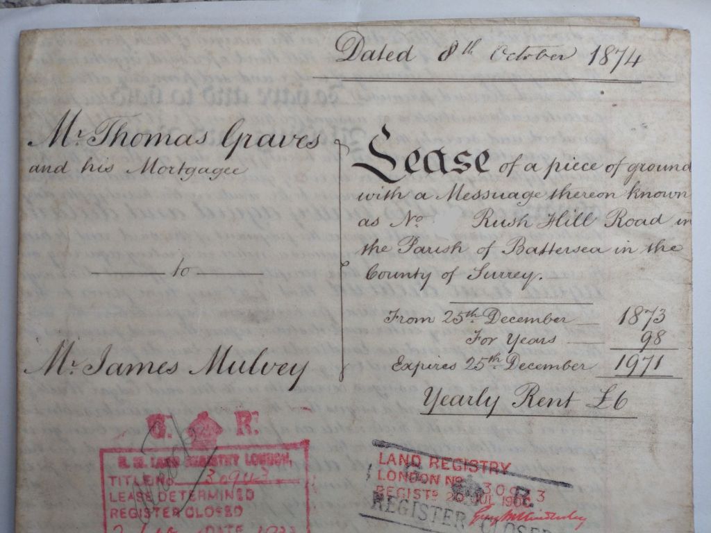
Thomas Graves only built one house on Rush Hill Road – Number 1 – which seems to have been a bit of a show home for what could be built along the rest of the street (and if you look closely, the brickwork between No 1 and No 3 still has a visible dividing line). He then sublet the rest of the land along Rush Hill Road itself to James Mulvey who, sticking with the theme of everyone becoming a builder, had until then been a printer and lead trader based on Euston Road.
The leases – one of which is pictured below, and which include James’ signature and wax seal pictured above, would run for 98 years for an annual rent of £6 per house (although most of the houses ended up being bought as freeholds well before the end of the term).
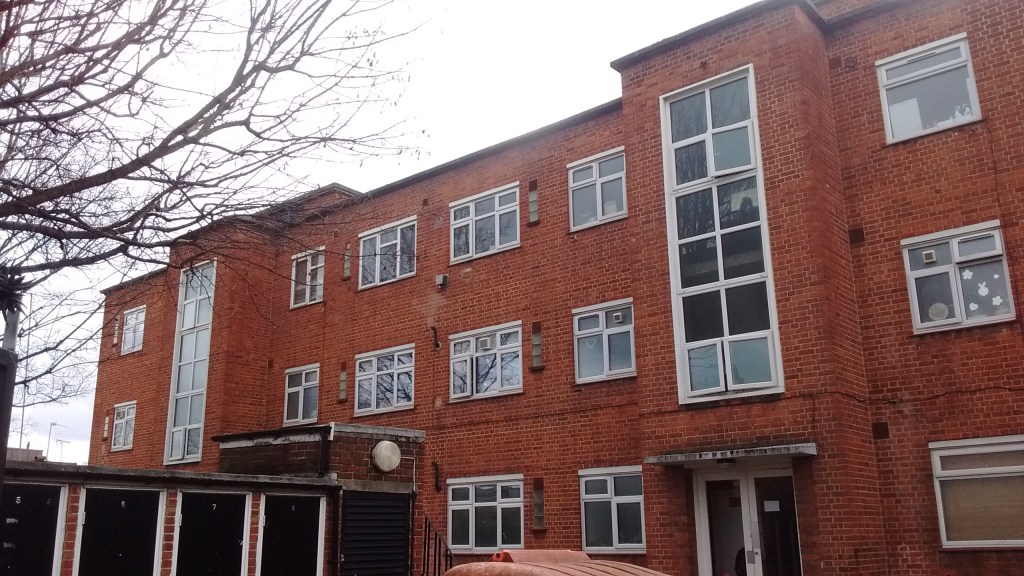
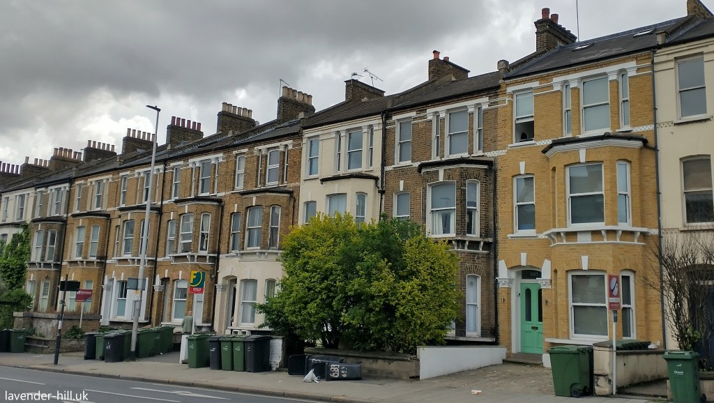
It was James who built the two big terraces (each of 15 houses) pictured below, in 1874 and 1875. Thomas set out quite a lot of conditions in leasing the land to James, mostly aimed at ensuring the the street was built to a high standard, essentially echoing the design of the one house Tomas had already built: James had to “complete and finish fit for habitation in every respect and with the best materials of their respective kinds and in a good substantial and workmanlike manner and of the value of three hundred and fifty pounds at the least” – about £32,000 in today’s money. James also had to “complete a footpath six feet wide with a proper stone kerb“, and to build smart walls and fences around the houses.
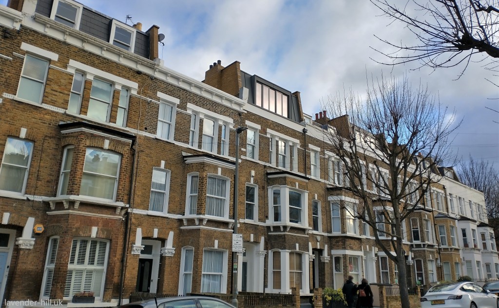
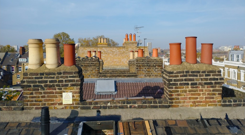
The North-London origins of both Thomas and James are also somewhat evident, as these houses originally all had front parapets with a cornice, pictured below. Parapet walls like these were usually chosen on main roads, or the typically more expensive streets north of the river, as they were more expensive and complicated to build; using them on a cul-de-sac in south London was rather unusual.
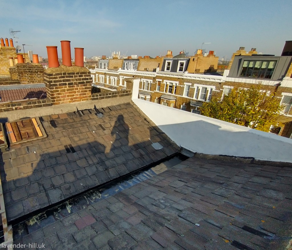
Behind these parapets were London butterfly roofs made of Welsh slate, with a V-shaped roof and a central gutter draining towards the back of the house – again something more common north of the river, in contrast to the visible roof and chimneys more typical of other houses away from the main roads in Battersea.
At the same time another local builder, Mark Chamberlain, had sublet the 300-foot street stretch of Lavender hill along the north side of the plot and was building Rush Hill Terrace. To the west of Rush Hill Road he built six particularly large and ornate four-storey houses between 73 & 83 Lavender Hill, each complete with double-height bay windows and a North London-esque steep flight of steps up to the front door to give the best views from the front rooms.
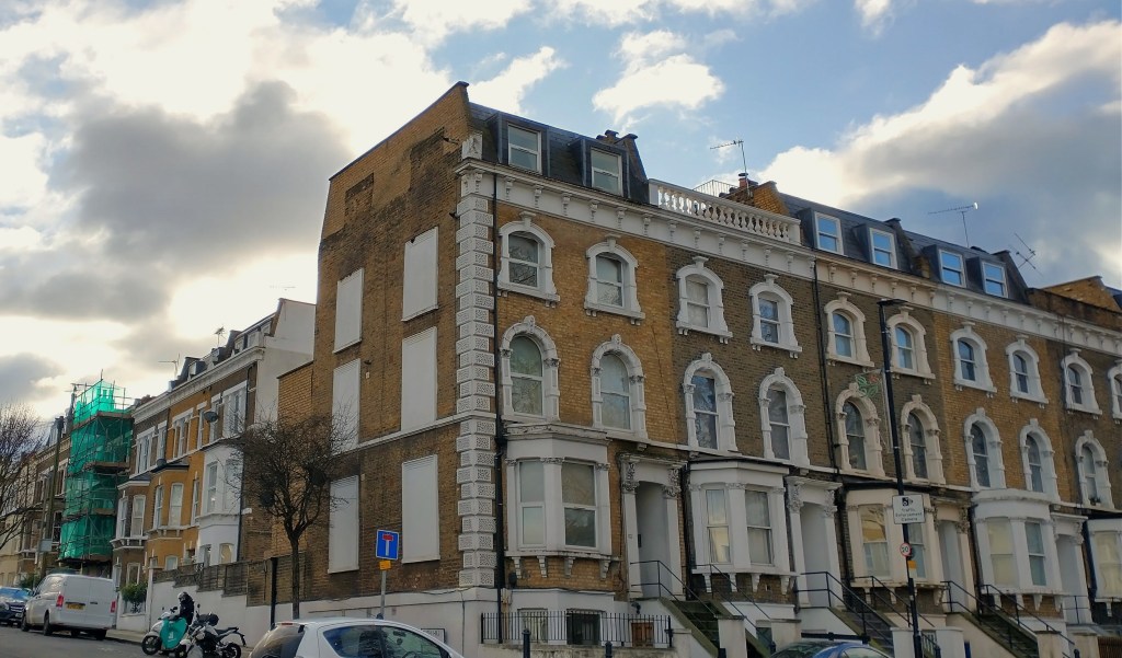
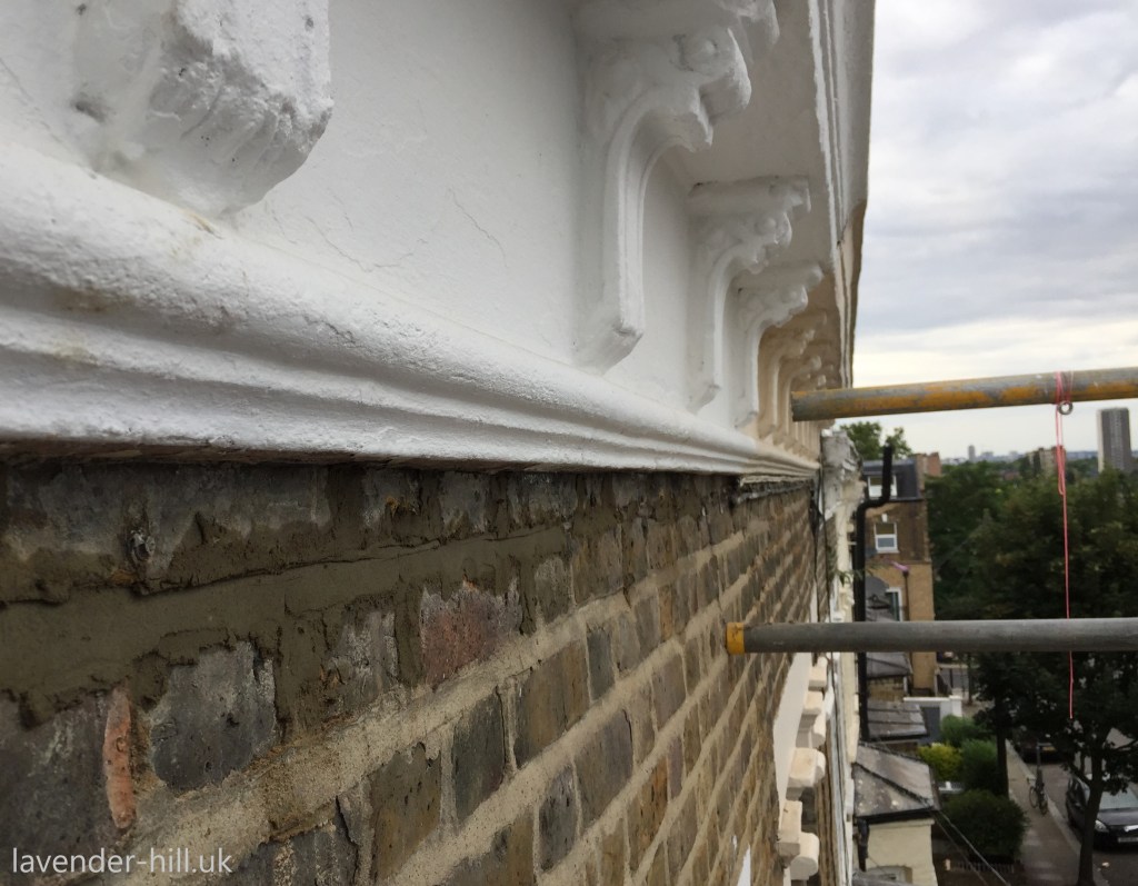
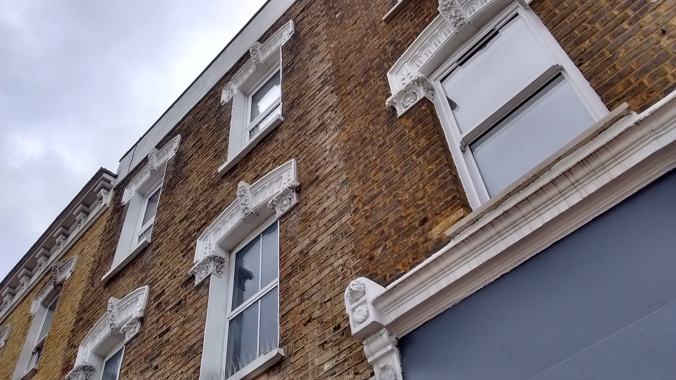
Mark understood that first impressions mattered when selling Victorian houses, and clearly liked to make his houses look more impressive by using good-quality decorative stonework around the doors and windows, as well as in the large cornice. The stonework – pictured below, albeit all now painted over as became the fashion – was actually an innovative form of terracotta, all supplied by famous sanitary engineer George Jennings of Lambeth, who had developed a profitable side business selling intricate moulded stone to decorate houses all over the Clapham area. This was a high-end product and it didn’t come cheap: the money ran out during the construction of the terrace, and the houses were briefly mortgaged to Jennings to pay for the stonework!
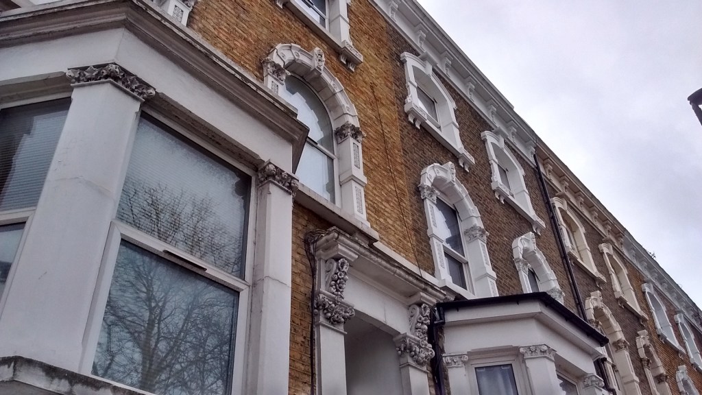
To the east Mark built a row of slightly simpler three-storey houses with shops on the ground floor, at 57 to 71 Lavender Hill; pictured below – without baty windows, but once again showing his liking for George Jennings’ distinctive moulded-stone surrounds above the windows. These houses, as well as those along Rush Hill Road, originally had ornate balustrades on top of the parapets, but almost all have since been removed or replaced – we don’t know why but presume that there must have been a bit of a structural issue with the original design at some stage.
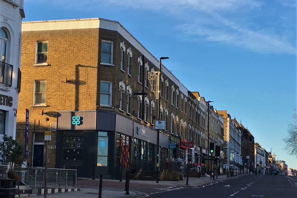
Mark later leased more land further to the east and extended his row of shops with houses above all the way to Taybridge Road (from No. 55 all the way down to 29 Lavender Hill, encompassing what is now the Co-op supermarket – pictured below). He used the same design; albeit a small gap is still visible in the brick between No. 55 and No. 57. Mark was a really prolific local bulder, and was clearly on a bit of a roll at this point as he went on to build even more of the same design to the north of Lavender Hill on the now-demolished southern section of Tyneham Road, as well as The Craven pub on the left of the photo below (originally in contrasting red brick), as well as big terraces of houses nearby at 2–18 Taybridge Road, and 33–41 Stormont Road, and even more houses further down Lavender Hill, as well as a gigantic five-storey terrace at 70-82 The Chase (which also has the same window surrounds as his Lavender Hill terrace).
One surprise is that despite the explosion of building work in 1874, the original Rush Hill House villa was not demolished. Despite its garden and driveway being replaced by eight shops and forty six terrace houses, and the western outbuildings and stables being demolished to make way for the new road, the main body of the house just got incorporated in to the new development and stayed in place for another fifteen years, jammed in behind the shops in Lavender Hill and now known as the somewhat less glamorous ’63 Lavender Hill’. Why this was done remains a bit of a mystery, and having a big old house jammed in to such a small space must have been a strange state of affairs. What we do know is that the last occupant of the old house died in 1887, at which point the remains of the villa and a small bit of garden were sold at auction and redeveloped – once again by our ever-active local builder Mark Chamberlain – to build the Mews. This unexpected life-extension for the old villa probably explains why Mark’s previous houses along Lavender Hill to the west of Rush Hill Road were built as grand houses with back gardens, while the ones he built to the east were built with more modest shops on the ground floor and buildings running to the back of the plot (pictured below): there simply wasn’t space for back gardens there, as there was still a giant old villa in the way!
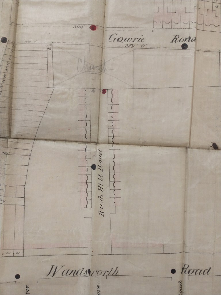
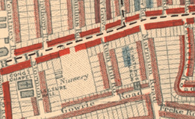
The original approval for the road included a condition that it be extended all the way to the edge of the plot, to allow a link to Gowrie Road, which had been developed as the Lavender Hill Park Estate by a different developer. A piece of land had been left unbuilt along the north side of Gowrie Road to provide for a connection. However amid slightly unclear circumstances, the land was instead donated by the developer to Reverend Erskine Clarke of Battersea to be a new church; the ‘Church’ plot is pencilled in in this map of that estate drawn part-way through its development, which we think is showing the plans for gas lighting by means of red and black dots:
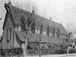
St Matthews Church was designed by William White, who also designed St Mark’s on Battersea Rise, and built by W. H. Williams. It had an Early English style supposedly reflecting 13th century designs, including a vaulted roof and sacristy, and a small churchyard on either side that allowed access from Rush Hill Road to Gowrie Road. It could seat 550 and cost about £3,000 to build (about £400,000 in today’s money). It opened in April 1877 – two years after works had reached completion on Rush Hill Road.
It started life as a daughter church of St Mary’s Battersea, and was served by curates from that parish. In 1895 a new parish was created to reflect the growing local population, and at first it was assumed that St Matthew’s – which was squarely in the new Parish – was finally going to get its moment in the limelight and would of course be the church for the new parish. However the Ecclesiastical Commissioners insisted that the building was not substantial or impressive enough, which led to the bigger and more prominent church instead being built at St Barnabas, at the top of Battersea Rise instead. St Matthew’s was again relegated to being a daughter church of St Barnabas.
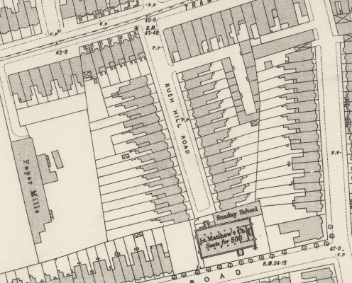
This permanent second-rank status meant that St Matthew’s was never a great success. The somewhat unloved church continued to be see some use until 1941 when it was permanently closed. Soon after closure it was damaged (but not destroyed) by bombing in the War. It lingered on for two more decades in increasingly decrepit condition, before finally being demolished in the early 1960s, leaving an open space that for some time was used as car parking and as an informal neighbourhood play area. Demolition paved the way for the site to be sold to Battersea Borough in 1967 for redevelopment as Council housing. Not many records remain of the Church, maybe reflecting its limited use in its later years, and the only photo we’ve found is the one to the above showing the Church from Gowrie Road – however it is shown on most maps, including a ‘Sunday School’ building between the Church and the start of the terrace of houses on Rush Hill Road. It’s not been completely forgotten at its old ‘parent’ Church though – as St Matthew’s old communion plate is still in use at St Barnabas.
The block of 12 flats built on the site (eight of them with two bedrooms, and four having one) has no name – and despite having a somewhat hidden garden area, it seems to have made no reuse of any of the elements of the old church in its landscaping.
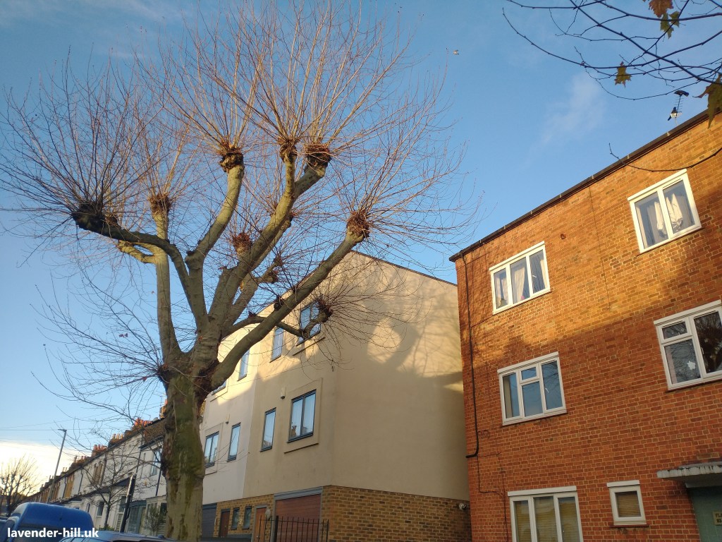
One feature of the church has survived though: two large London Plane trees on Gowrie Road, and the huge one at the south end of Rush Hill Road, are the same trees as in the photo of the Church above. The access path through the churchyard was also made permanent as a narrow alleyway, Rush Hill Passage, connecting Rush Hill Road to Gowrie Road.
The houses on Rush Hill Road were unusually large houses for Battersea – they all had two reception rooms on the ground floor connected by a double door, and four large bedrooms on the upper floors. They had a bathroom, and two WCs right from the start (one on the first floor and one outside), and a kitchen and a separate scullery.
The ground floors were built to impress with solid brick walls throughout, thick oak doors, and cornicing and high ceilings – while cheaper materials were used on the upper levels where it was less important to impress visitors. The houses had gas lighting, and each house also had eight fireplaces for heating.
The shape of the original plot of land meant that one street could be fitted in with plenty of room to spare, but fitting two in would be difficult – which led to one of the distinguishing features of the street, in that the odd-numbered houses also have 90-foot back gardens, which are enormous compared to the 15-20 feet more typical of many other houses in the Lavender Hill Park Estate next door. The walls between the gardens were built of brick rather than wood, and some of them still survive. The houses also have an extra five feet or so of garden at the front, which would typically have been planted with somewhat exotic plants when the street was first developed.
The huge amount of space behind many of the houses is also where one of the more mysterious design choices emerges: having eight fireplaces in each house implied a considerable amount of coal being delivered on a regular basis; which in a middle-class house would usually mean either a ‘coal hole’ (a drain cover in the front garden or pavement that led to a coal storage basement), or a pathway running behind the houses with gates to the gardens (where it could be delivered to a back garden coal store). These houses had neither, despite having plenty of space to accommodated a rear entrance passageway; so all the dusty coal had to be carried through the front corridor.
Another unusual feature is that the houses are not built in symmetrical pairs. Typically a terrace house puts every second house the other way round, so that the doors are in pairs next to each other and the back extensions can share a wall and chimney stack – meaning a big chimney is only needed every two houses because chimneys are shared between two houses. In Rush Hill Road every house (apart from No. 1, which was built by a different builder) is built the same way round. This is a bit more visible with the photo below, taken from the back of the houses, where every roof of the rear wings is angled the same way, showing that all the houses had the corridors and staircases on the right hand side of the house.
Building like this needs more bricks and effort; and seems to be another sign of the North London origins of all the developers – being done purely to create a more regular spacing of the bay windows and doors at the front of the terrace. The grander terraces north of the river were typically not built in pairs, as it was seen as slightly upmarket for each house to clearly had an independent entrance that was not immediately next to the entrance to the neighbouring house.
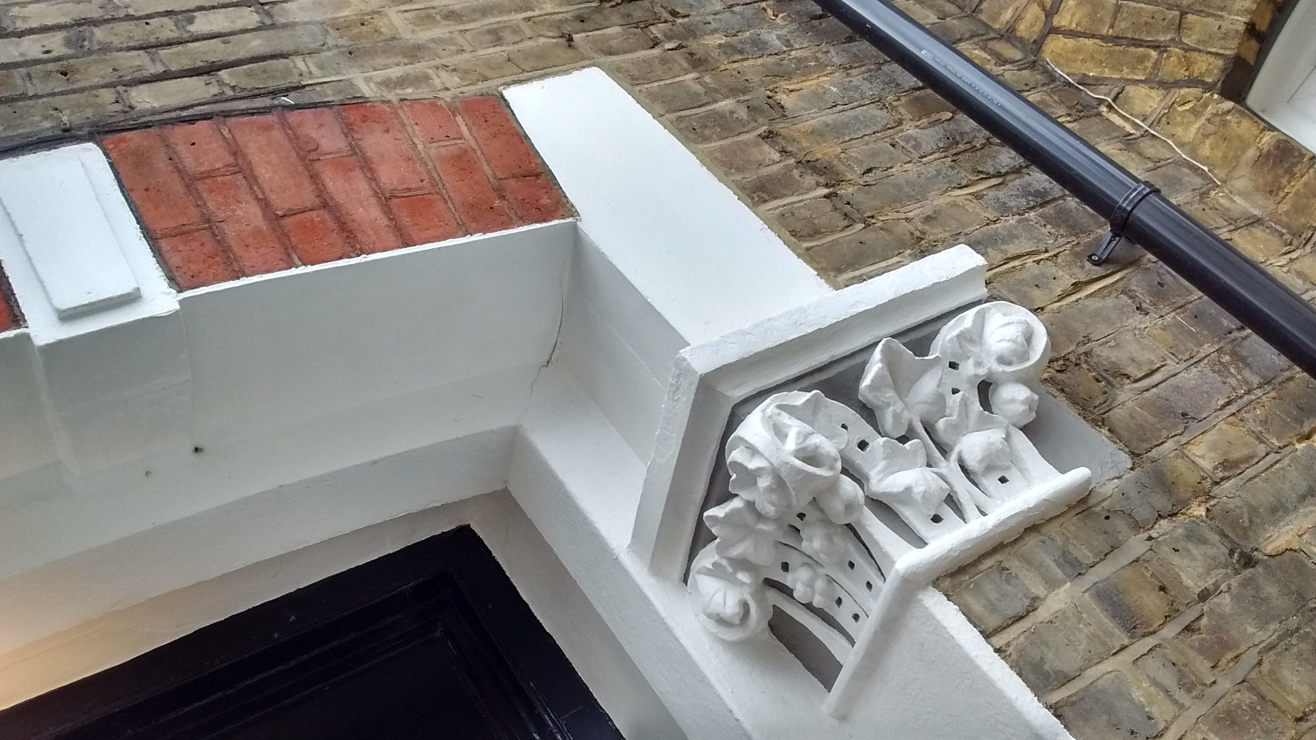
James Mulvey seems to have also had an account at George Jennings, and while his Rush Hill houses did not feature any window surrounds, the budget did stretch to include a different stone moulded capital for each house either side of the front doors. These pass mostly unnoticed now, but would have been part of the marketing of the houses in their day, and came at some cost to produce. A good few of these stone capitals seem to be based on various Acanthus plant designs – a long established Greek design that became very fashionable in the 1870s – but ivy, ferns, fruit, and in just one case (at 22 Rush Hill Road, and possibly a special request by a Victorian buyer) a king and queen also feature. The terraces also have a band of diamond-patterned stone running the whole length of the terrace just below the windows on each floor.
The big Rush Hill houses proved popular with the middle classes; selling quickly. They stayed pretty desirable, and we have some idea of how they were doing 25 years later in 1900 because Charles Booth – in his huge project to map out poverty and wealth right across London on a house-by-house basis – visited Rush Hill Road and categorised it as pink, which was code for “Fairly comfortable. Good ordinary earnings.”. Mark Chamberlain’s houses along Lavender Hill – which were larger – were shaded red, the second highest category, representing “Middle class. Well-to-do.“.
This reflects a pattern that was to change drastically as card came on the scene: the big grand houses on the main roads were the best houses for the richest people. Only when these became traficky thoroughfares, did things change – at which point these huge houses were typically split up in to smaller flats for the less wealthy, while the quieter houses on the back streets remained desirable. The previous failure to make Rush Hill Road a through road, thanks to the unloved St Matthew’s Church, also started to play to the advantage of Rush Hill Road which – thanks to being a cul-de-sac – remained a rare traffic free street in the area.
The map Booth was using wasn’t especially accurate: St Matthew’s is in the wrong place, Rush Hill Road was shown as connecting to Gowrie Road (it never did), and Craven Mews / Rush Hill Mews is completely missing. Booth spotted the latter anyway and shaded it light blue, as shown below, which was code for “Poor. 18s. to 21s. a week for a moderate family“. It also suggests that despite the original rule that the mews were never to be converted to dwellings, this had already happened by about 1900 as someone was clearly living there!
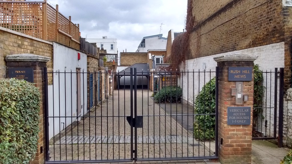
Not much changed over the next century. The mews, built as stables, somehow got renamed from Craven Mews to Rush Hill Mews. The original stable blocks were demolished in the 1930s and replaced twenty lock-up garages with corrugated asbestos roofs.

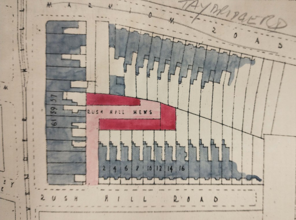
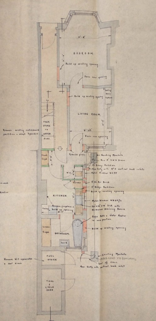
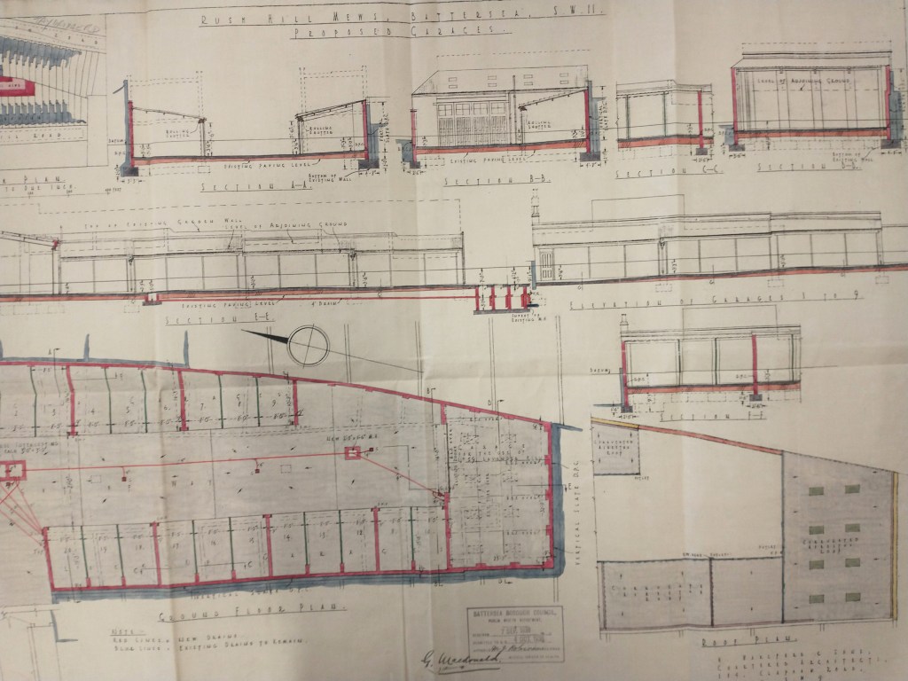
The image above shows the layout of the original stables and coach houses in Rush Hill Mews, and the one below is from the proposals to demolish them and replace them with garages. They show an interesting feature of early ‘planning applications’, in that the Council wasn’t too worried what you built or what it looked like, as long as the sewerage arrangements were up to an adequate standard! Most of the early plans in Wandsworth Archives are showing proposed drainage setups, which had to be submitted for approval – reflecting continued caution after huge cholera outbreaks that had taken place in London in the 1830s and 1840s,
As ever, the coach houses would by the 1930s have seemed old fashioned, and ready for replacement with something more modern and suitable for cars – but the new garages, which were fairly small and which had asbestos roofs, eventually also became obsolete as cars got larger, and were demolished in 1996 and replaced with five houses with their own external car parking.
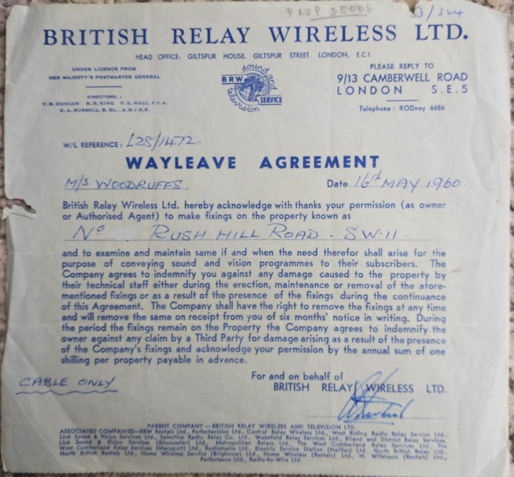
The houses gradually saw electric power installed, and the old fireplaces gradually gave way to gas fires and modern heating systems. The houses had seen electric power installed from the early 20th century, and an early cable TV system was installed by British Relay Wireless Ltd along the terraces in 1960 (a wayleave agreement for the cables, which ran just under the front parapets, is shown below).
The 1960s and 1970s saw a gradual decline in the fortunes of Battersea, as its remaining industry and employment along the riverside faded away. There weren’t many takers for the large, draughty old houses of Rush Hill Road! The houses along Lavender Hill were almost all split up in to smaller flats that were easier to sell, while the Solon Wandsworth Housing Association saw an opportunity to build a portfolio and bought eight of the Rush Hill houses, splitting each one in to two flats. By now modern records exist in the archives, including detailed building inspector reports – and we can see that the work involved was sometimes considerable, including comprehensive upgrades to the infrastructure of what had in by then become fairly dilapidated houses, and in several cases extensions so that both upstairs and downstairs flats could have access to parts of the large gardens. Solon went on to build up a portfolio of 1,100 houses in all, before being forced to merge with Wandle Housing Association in 2004, after a review by the Housing Corporation – following concerns about its finances and what was described as ‘unorthodox’ management – decided that Solon was “unmanageable” and had made poor decisions that put its whole business at risk. The forced transfer of all Solon’s houses to another housing association was very controversial, with accusations made that Solon’s assets (including those of many tenants with shares in the association) were being stripped, and that Wandle had “hit the jackpot” in getting hold of all these by now rather valuable houses – but it went ahead nonetheless, and although a few of the houses Solon had taken on have since gone back in to private ownership, Wandle still manages several houses on the street.
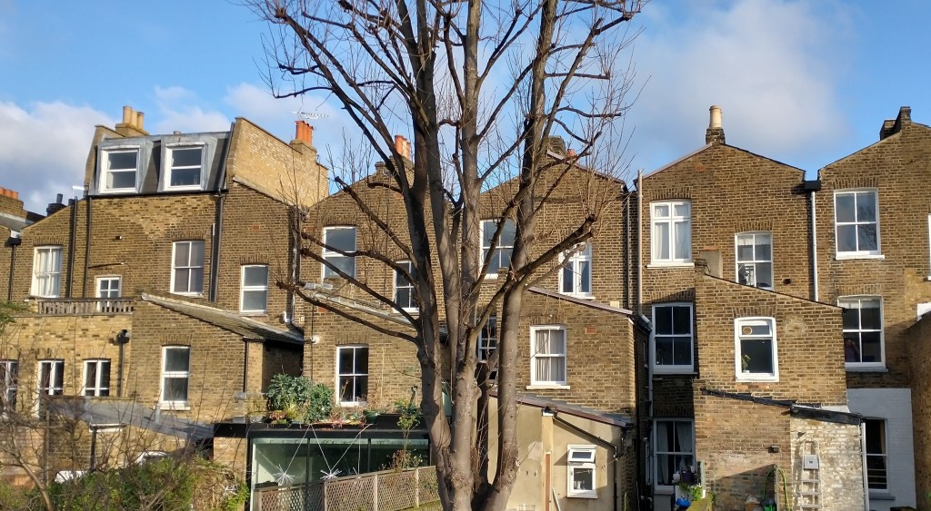
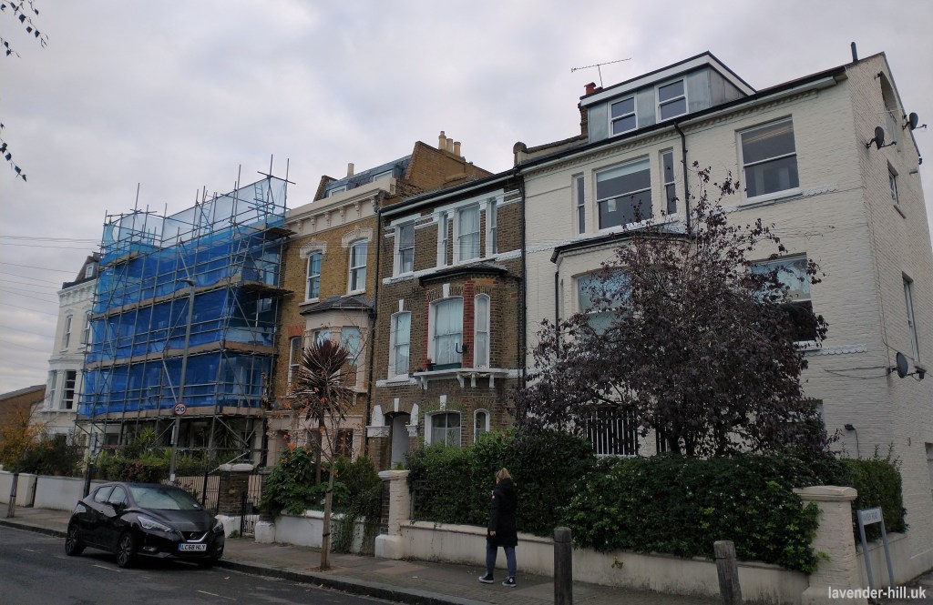
From the 1990s onwards Battersea’s popularity for families grew, and as the area’s popular state schools, proximity to Clapham Common and generally decent housing saw what had been seen as a rather gritty and industrial neighbourhood “rediscovered” by wealthy professionals. The seeds of gentrification started around Northcote Road, but as a trickle of development became more of a tidal wave it swept out down the Lavender Hill, with process exploding and developers seizing opportunities right left and centre among the unmodernised houses. Rush Hill Road was no stranger to this process, which saw several of the houses that had been spit to flats recombined to single houses.
Many of the houses saw extensions upwards and backwards – many going from three to four storeys as the butterfly roofs proved particularly easy to turn in to an additional floor. Rear extensions appeared right left and centre, and scaffolding became an increasingly present feature of the street as the houses saw ever more substantial renovations and modernisations to develop modern living accommodation.
Rush Hill Road’s tall terraced houses with their parapet rooflines are slightly different to the rest of the Battersea backstreets – but they’re by no means unique, as they have a sister terrace on Wandsworth Road close to its junction with North Street, which we think was also built by James Mulvey (pictured below). Apart from lacking a parapet, and having a more conventional roof running side-on to the road, these houses are exactly the same design as the Rush Hill Road houses – even down to the two arched windows in the original front doors, the band of diamond-patterned stone running along the terrace under the forst and second floor windows, and the moulded stone capitals either side of the doorways. Again they are not built in alternate left-handed and right-handed versions (hence a lot of chimney stacks, and rather more complicated back wings than would usually be built).
More intriguingly, there’s also a single house at 43 Stormont Road of the same design as the ones on Wandsworth Road, marooned amid a series of completely different designs by other builders involved in the building of the neighbouring Lavender Hill Park Estate (it’s the darker-coloured one in the middle of the terrace shown below); which was built in 1876, a couple of years after the start of work on Rush Hill Road, by Thomas Graves – the one who had built the very first ‘show home’ at 1 Rush Hill Road, before selling off the rest to James Mulvey. The white-painted house to its right, 45 Stormont Road, was also built by Thomas and looks like a ‘stretch’ version of the Rush Hill Road design, taking a space that could almost have accommodated two houses – with its entrance at the side. Quite what was going on on this piece of land is a bit of a mystery, as it was unusual and not very efficient to build a terrace of just two houses, especially with one stretched and one not! Meanwhile the four houses to its left – somewhat covered by scaffolding in our photo – also have all the signs of being a miniature development by Mark Chamberlain (the one who built so many houses along Lavender Hill), as they have the tell-tale expensive window surrounds.
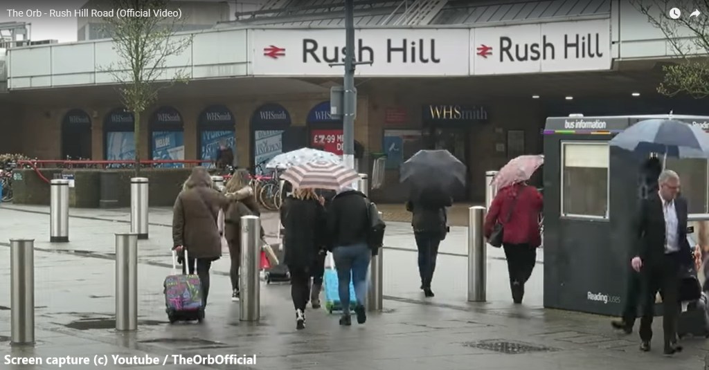
This brings this history to the close – with Rush Hill Road continuing as as a popular place to live, a far cry from its beginnings as a smart country house up on the hill with views of the Thames. However one final claim to fame for Rush Hill Road is that it has a track by The Orb named after it, Rush Hill Road, released in 2018. We know that The Orb’s co-creator and longest-running member Alex Paterson grew up locally and still lives nearby, and Battersea sees a good few references in their wider work. Keen-eyed viewers will notice the music video features Rush Hill station (which has more than a passing resemblance to the old entrance to Reading).
If you find our occasional and typically over-detailed local history articles of interest, you may enjoy a long article on the complicated history of the Cedars Road estate, a similarly detailed look at the past of Culvert Place, a photo story about the Shaftesbury Estate drawing on its conservation designation, an article about the cluster of derelict buildings around the old Artesian Well bar on Clapham North street, and an article about the area around Falcon Lane (big Boots & Asda) that dives in to the area’s messy past and some scary 1970s road-building projects that very nearly got built!
Special thanks to the staff of Wandsworth Heritage Service, and to those on the street who shared bits of useful knowledge and assorted old documents as we wrote this article.

Incredible amount of research ! Where do you find the time, it’s still a mystery (and don’t tell me you wrap it up during a boring video meeting !) 😉 Congrats!
Cyril Richert
LikeLike
This is really interesting – thanks for taking the time to post it. Do you go to the archives and research in person? I’ve been looking at the history of my own street (Mysore Rd) online, but haven’t found anywhere near this level of detail!
LikeLike
Pingback: pHresh Juice, a new juice & coffee bar on Lavender Hill | Lavender-Hill.uk : Supporting Lavender Hill
Pingback: Like a cat: Clapham Common’s most historic house escapes demolition yet again! – Clapham Junction Insider – Local Democracy Reporting
Pingback: A house with more history than most: Double blue plaque unveiling on Lavender Sweep this Saturday | Lavender-Hill.uk : Supporting Lavender Hill
Thanks for all your amazing research, it’s really enlightening. Our ancestor John Harvey lived in one half of Rush Hill House with his wife Louisa Hall and their seven children, and the Ashlin family lived in the other half. John Harvey was born in Colchester in about 1780, and with connections to the wool and silk trades by 1810 he had set up in business with James Lamming as mercers. After a few years in business, John Harvey became the proprietor of Harvey & Sons in Ludgate Hill – a shop with a long and interesting history – and he married Louisa Hall, daughter of silversmith George Hall and half-sister of merchant Richard Coward. We have many stories about the Harvey and Hall family, both their ancestors and descendants, and their marriages. Also a few ancient photos in digital format. When John and Louisa Harvey and their children were young, they lived over the shop in Ludgate Hill, and may have moved to Battersea after the construction of the new London Bridge brought improvements for commuting by coach. For Rush Hill House to be sold in 1872 suggests that John Harvey continued to reside there until the end of his life. Thanks for providing so much information about the Harvey home and what happened next.
LikeLike
Pingback: Factory developers, social reformers, fearless pilots, celebrated artists, tenacious campaigners and ‘dangerous subversives’: the pioneering women of Battersea’s early days. | Lavender-Hill.uk : Supporting Lavender Hill
Pingback: Shapurji Saklavata, Battersea’s controversial one-of-a-kind MP in the 1920s, will be recognised with a plaque this Friday | Lavender-Hill.uk : Supporting Lavender Hill