
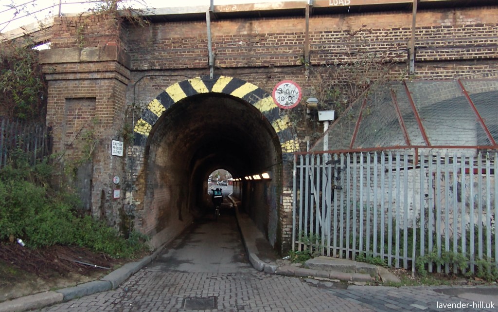
It’s best avoided after dark. A winding footbridge, with suspicious yellow puddles and high walls either side that are hard to see over, followed by a big and somewhat muddy yard with stacks of flytipped debris, where you’re completely on your own, a long, dark, narrow tunnel with no pavement, and a final section that smells of pigeons.

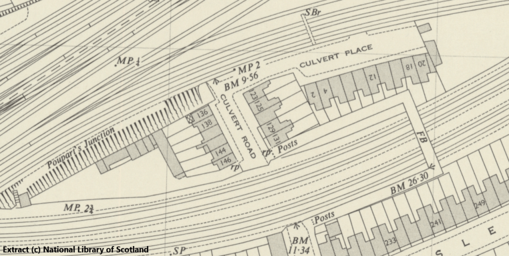
No-one likes the bit of Culvert Road between the railways. But it wasn’t always like this – and it turns out there’s quite an interesting history to this forgotten corner of Battersea. For starters – there are no houses there now. But as the old map below shows, there used to be 21 houses here!
A small community lived here for nearly a century, in neat terrace houses along both Culvert Road (the road that heads on through the tunnel) and Culvert Place (the road that heads east, before diving back under the railway arches to the Parkfield Industrial Estate – home to Caffe Nero’s UK roastery, which incidentally is why the whole of Lavender Hill occasionally smells of roasting coffee beans in the morning).

Victorian researcher Charles Booth famously walked round the whole of London and mapped out the relative wealth of the inhabitants, with a view to identifying where the poorest and most marginalised populations lived. He visited Culvert Road in June 1899, accompanied by Police Constable Edwards (of District 36 – Battersea East), and as his colour-coded map above shows, he reckoned that Culvert Road’s residents were ‘Mixed – some comfortable and others poor’ (about the middle of the scale overall), while Culvert Place’s inhabitants were “Poor. 18 to 21 shillings a week for a moderate family”, which suggested the district was slightly less well off than the Shaftesbury Estate to the south.
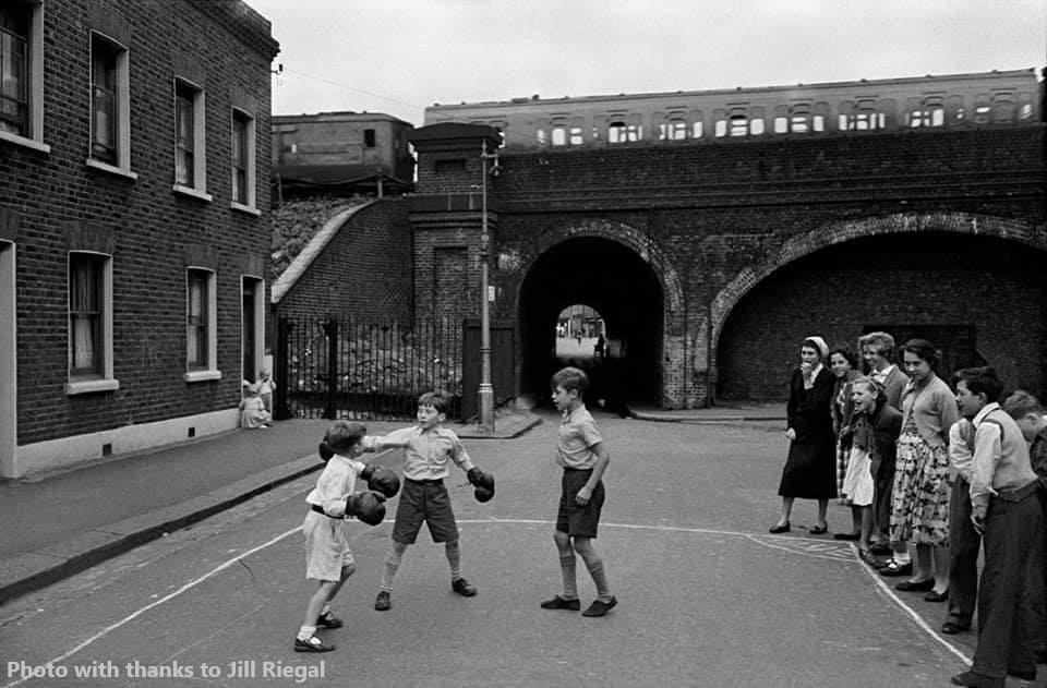
The photo above – via the ever resourceful members of the ‘Battersea Pictures’ Facebook group – shows two of the houses & several of those who lived there. This was a happy little community by all accounts, that just happened to be in the middle of a series of railway lines. The photo below, taken slightly further along Culvert Road in front of another set of now-demolished houses, shows much of the street celebrating VE day.

The houses between the railway tracks on Culvert Place were also known for having a small memorial to the many loved ones that the small cluster of families living there had lost in the war. This stood out among memorials, for its modesty – a simple wooden affair – and for the loving care that it received from the community for over 20 years.

And it wasn’t just the terrace houses who brought this area to life, as the area between the railway the western end of the land was also home to a long established Romany Gypsy community – as pictured below in a photo taken in 1900. The 1911 census lists members of the Winter, Lee, Wheeler, Smith, Botton and Anderson families as residents, as well as the Mills who owned the yard.

The photo below is one of a collection assembled by the Romany & Traveller Family History Society, one of whose members was passed a few photos of the yard and residents by a friend who was a documentary film maker who had researched a possible film about the Mills family, who had been in the area for some time and had an involvement with the local boxing club.

The society put out a call for information about the old yard and the family, not being quite certain where it was in Battersea but assuming it had long since been redeveloped like many other similar sites that were once scattered through Battersea and Wandsworth, and to their surprise (given the amount of change this little corner of Battersea has seen) Tony Mills promptly got in touch confirming that the yard is still there many decades later – and still owned by the Mills family! It’s tucked away behind what is now Culvert Tyres, and is still very much in use, also being home to The Field Kitchen Company (who hire high-quality mobile kitchens to events). Mills Yard was just one of the many parts of Wandsworth’s rich Romany Gypsy & Irish Traveller heritage – with the map below showing many of the other now-lost sites around the Borough.

We didn’t draw this map, it’s from Summerstown182, which is one of the other sites we consistently recommend – and which really puts our occasional efforts at local history reporting to shame! They have just run a walk visiting many of these sites, to explore and celebrate this little-known part of Battersea’s past – the photo in the flyer below is of course taken from Culvert Road bridge, albeit not directly facing Mills Yard.

But this little community between the tracks was about to be torn apart. The houses were all, we understand, demolished by the Council between 1968 and 1972. Exactly why remains a bit of a mystery, although there was a deliberate policy at the time of clearing out ‘old’ housing – especially when it hadn’t been upgraded with the modern kitchens and bathrooms expected at the time – and replacing it with the giant estates that were very much in vogue. We suspect that this little cluster of houses was just thought to be too isolated, and too close to the railway.
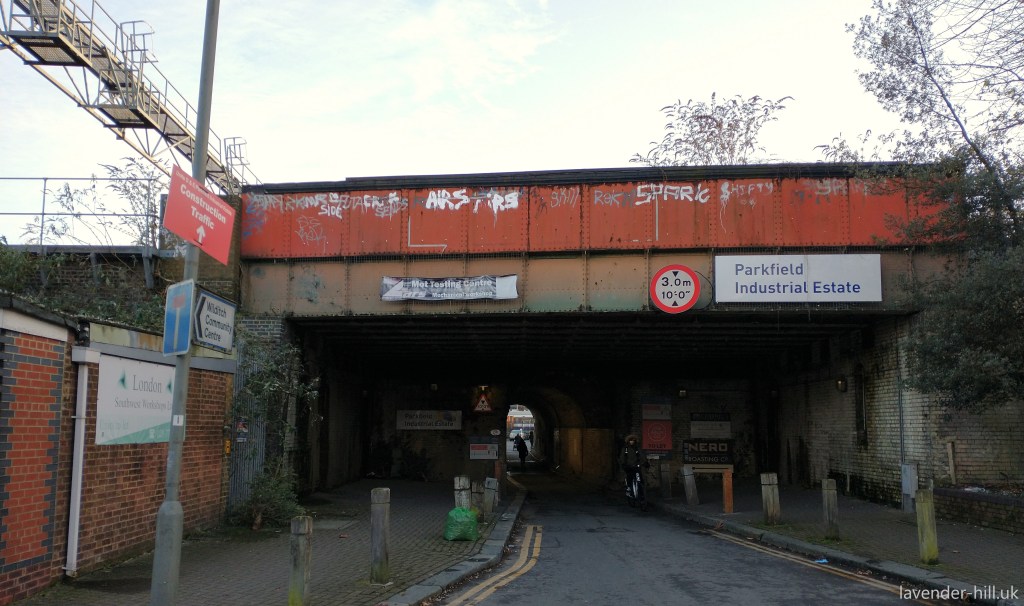
Culvert Road and Culvert Place weren’t the only bits of Battersea to meet the wrecking ball. Another set of similarly railway-centered houses a short walk along the railway met a similar fate, and became what is now known as Banana Park. But while Banana Park has gone on to become a reasonably successful green space, no-one can really say that the destruction of Culvert Place improved matters: the contrast with the same spot today – pictured above – is quite marked, and unfortunately it’s all become bit of a mess. The footbridge & tunnel – technically known as “Poupart’s Crossing” – is too indirect, narrow, and hidden away to really feel safe at night, and having a load of corrugated iron structures and rutted paving along the route does nothing to help the sense of abandonment around the place.
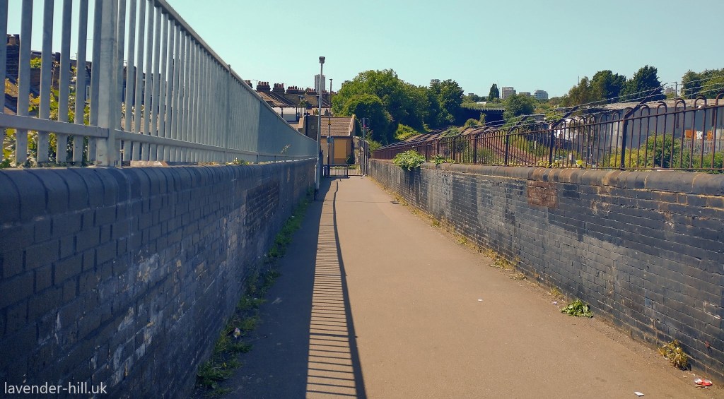
It used to be even worse: the tunnel was created as a private access route to what was, at the time, a large market garden owned by Samuel Poupart in what is now the Shaftesbury Estate, but the southern set of railway lines were for many years crossed by a level crossing; which were so busy that they had to be staffed by a gatekeeper. When the Shaftesbury Estate was built the railways rather grudgingly built a footbridge, but it was a cheap and flimsy affair – five feet wide at and with steps that were too steep. Soon after this mediocre bridge was opened, a 1877 survey measured 4,372 adults and 1,725 children a day crossing the bridge; 420 people an hour – which was hugely overcrowding it with frequent accidents. A combined effort by the railway inspectorate, the Battersea Vestry, the Metropolitan Board of Works and the London County Council eventually managed to get the current bridge built, at public expense, in 1892 (and it was rebuilt in the same layout in) 1945 – and while better than what came before, this rather unappealing route across 400 feet of railway lands is still a significant barrier between North and South Battersea.
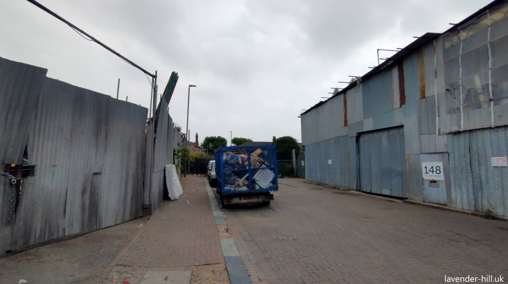
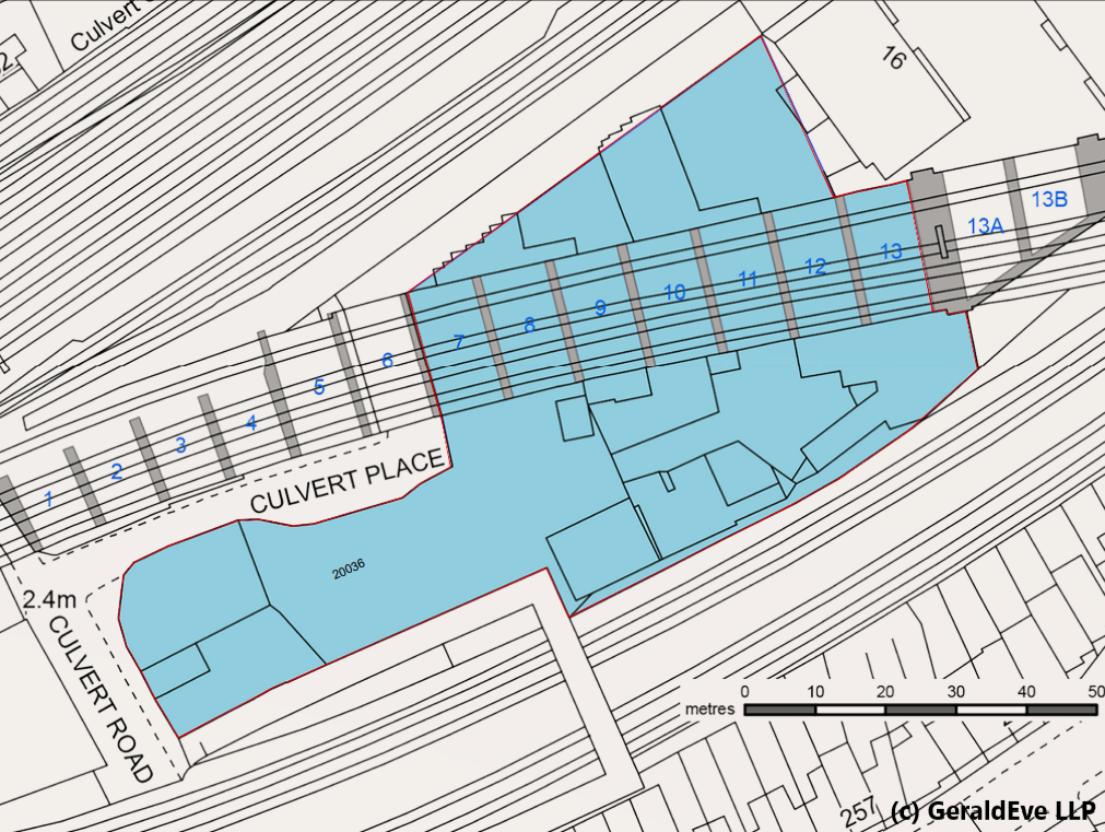
For many years, the larger of the two areas of cleared land was used as a store area by Metro Waste. Metro’s yard was always somewhat disorganised affair, overgrown at the edges, but with a substantial amount of space overall including no fewer than seven railway arches under the main railway, and two more miniature arches under the ramp up to the footbridge. These images from Geraldeve, the letting agent show how the yard actually runs under the railway through the arches, and continues on the other side.

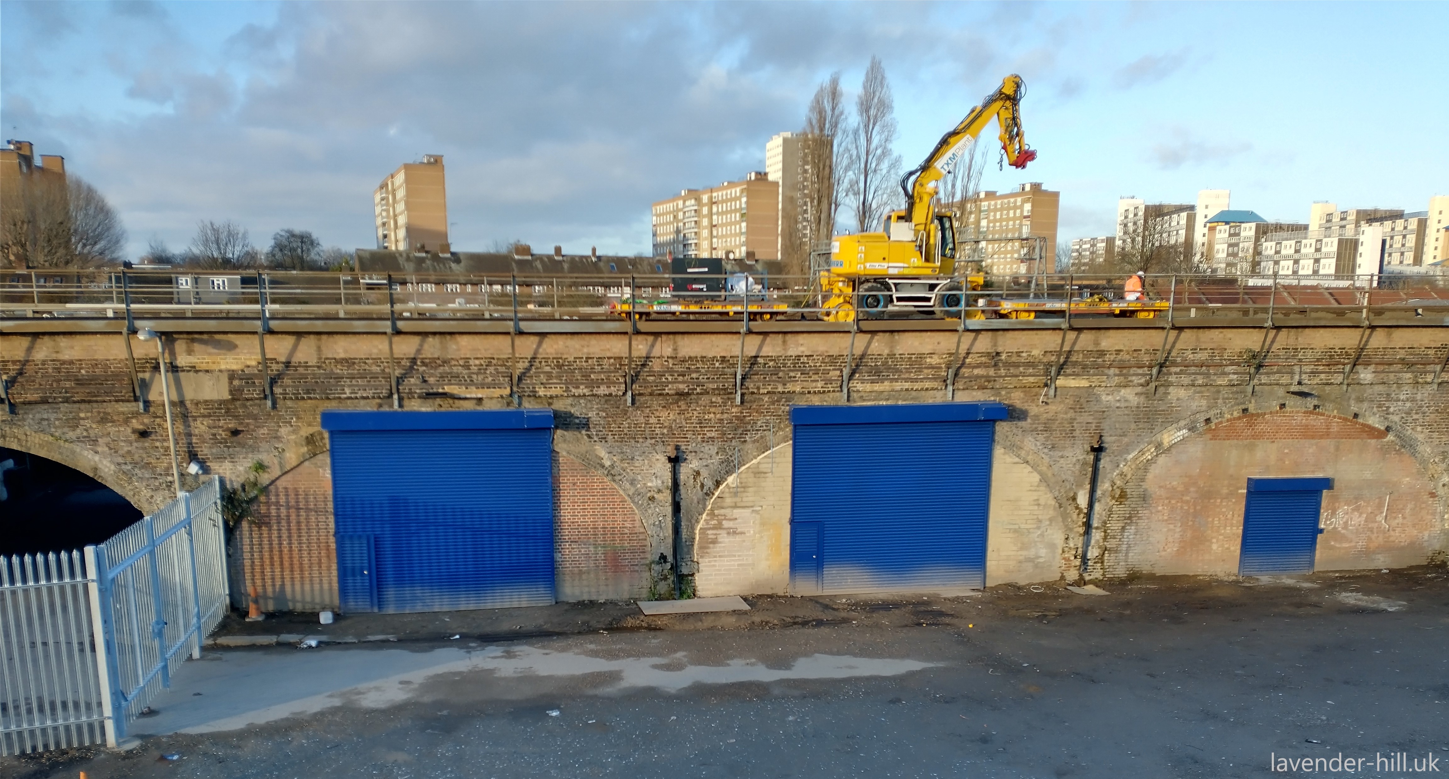
Metro Waste’s lease has recently ended, and the landlord has set about tidying the whole place up with a view to finding a new tenant. The photo below shows the yard from the footbridge, now that it has had a major clearout.

A proper fence has been put up around the site, replacing the previous ‘corrugated iron and scaffold poles’ assembly with something a bit more secure and somewhat tidier, and new roller shutters have been fitted to the railway arches. A vast amount of buddleia has been cleared away, and works are underway to level the ground.


It’s a huge space – with 11,789 square feet of arches, as well as 39,743 square feet of outdoor space! It’s likely to be quite in demand, as the sort of parking / delivery / vehicle storage dept that is becoming rarer and rarer in inner London. The landlord is also installing three-phase power and plans to pave the whole surface as well. It’ll be interesting to see who leases this – with an eclectic mix of neighbours including the Caffé Nero roastery, a large number of ‘dark kitchens’, motor repair shops and Chesneys almost any commercial or industrial use could fit in here; provided they don’t need lorries to large to fit through the rather slim tunnel.
But while the new tenants, whoever they are, are bound to modernise the place further, there is one set of people who’d rather like to preserve the rather down at heel nature of Culvert Place: Film makers! Because this motley set of backstreets and railway arches has had far more than its fair share of film appearances over the years.


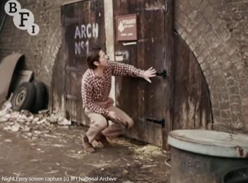
Maybe the one that makes the best use of the area is Night Ferry, which was filmed in 1977, five years after the houses were demolished. The screenshots above and below are a few of the large collection on Reelstreets, which show how the railways, the roads and the arches were used extensively – in these shots Engin Eshref (yellow top – working in a small tea stall) and Graham Fletcher-Cook spot the film’s villains hiding a stolen Egyptian mummy in the odd-looking railway arch right next to the tunnel.
The stills below show the stolen Mummy later being brought out of the arch and loaded in an ambulance, as they try to smuggle it out of London.


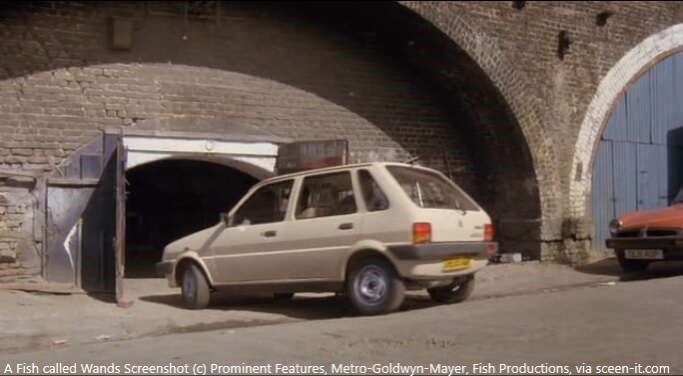
The rather curious-looking Arch 1 – with a miniature arch within the larger arch (which seems to be unique – we’ve never seen any other like this) was clearly in semi regular use as a film location for dodgy dealings, as it also features in 1998 classic A Fish Called Wanda, as the hideout place where the team hides the diamonds – here a getaway car enters the arch:
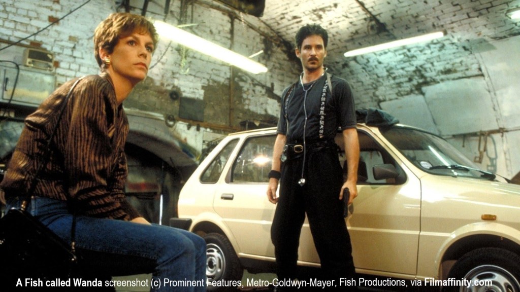
And almost uniquely, A Fish Called Wanda also gives us a shot of the interior of the arch, where we see Jamie Lee Curtis & Kevin Kline in a space looking much as you would expect an unloved railway arch in the late 1980s to look –
This spot has also featured in Villain, Minder, The Saint, numerous episodes of The Bill, and many more – more often than not in the context of some sort of Heist, and always as a suitably atmospheric and run down spot for dodgy activities! Arch 1 belongs to Network Rail, and according to an obscure list Wandsworth occasionally publish on business rates that shows which commercial properties are unoccupied, it and its neighbour been empty since February 2011.
Now that a large part of Culvert Place looks set to be converted in to a modern delivery depot, both its days as a tight knit community, and its days as a run down spot for stolen goods to be stashed away in movies, may be behind it. But we have to say – what started out as a short post on an unusual piece of land to let, turned in to a rather more interesting story of how Battersea has changed over the last century – and even our quick look has shown there’s more to Culvert Road than we expected.

It seems Culvert Road hasn’t been photographed much before the 1970s, but it’d be a shame for its past to be forgotten. If you have any more photos of the area when it was still lived in, that you’d be happy for us to publish here – or detail to add on its history – please get in touch.

Nice article. I for one would be truly sad to see this little oasis of pre-gentirifed Battersea “tidied up” too much. I often use the footbridge as a short cut when cycling from Lavender Hill to Battersea Park Road, and love the views you get across the railway tracks. Then there’s Culvert Tyres – the only car repair place I have ever found that is both brilliantly professional, quick, superb value, honest and above all friendly. I almost wish I still had a car so I could drop by for an occasional chat with SHak (I think was his name). Love the little tunnel too.
LikeLike
My family spent a lot of time growing up in this area including Blondel Road as well pre WW2 – Jon Willis
LikeLike
Came here after looking at a photo taken by Paul Barkshire (in his lovely book Other London 1983) of the pretty but flimsy huts that rather looked like Romany wagons without wheels! I have been going through the book trying to see what has changed in the intervening years and I guessed this would be one place that would have been swept away. I would love to hear from folk who lived in this odd wee spot and what day-to-day life was like for them.
LikeLike
I lived in prefabs hear , went to Christchurch school , I remember the old houses too !
LikeLike
My family use to have a coal yard down Culvert Rd called Brice’s Coal. Also the Hall family lived at 4 Culvert place. Does anyone have any memories of this?
LikeLike
I live here , sitting in my caravan writing this
LikeLike
hi Ben
LikeLike
I have a friend who lived there in the 50’s, 60’s & 70’s his name and a Bob Lewis. Do you know him or his family?
LikeLike
My family lived there in the 60s Anyone remember the Perry Family Tallest woman in London in the 60s Iris
LikeLike
Hi
LikeLike
Hi Bob
LikeLike
Pingback: The lost community & uncertain future of Culvert Road
this old coot lived on culvert Rd
https://discover.ukdataservice.ac.uk//QualiBank/Document/?id=q-a9a6e13d-cd2b-4ba1-8874-4f6577e356b3
LikeLike
Pingback: Shapurji Saklavata, Battersea’s controversial one-of-a-kind MP in the 1920s, will be recognised with a plaque this Friday | Lavender-Hill.uk : Supporting Lavender Hill